My formative years were spent in the Judean Hills, a mere 12 kilometers to the south of Jerusalem, nestled between Bethlehem and Hebron within the Jewish community of Efrat. In the eyes of the international community, it’s considered an illegal Israeli settlement in the West Bank, but for many, it is simply their cherished home within the region of Judea. Growing up, I gained a profound understanding of the multifaceted nature of our home. Each time I journeyed along the ever-shifting Route 60 heading south, the sights, vistas, terrains, and human activities served as poignant reminders of these intricacies.
During the late 1980s and early 1990s, the route to Efrat traced the ancient pathway that traversed the country’s mountainous spine. This historical route closely followed the watershed, linking major cities along the road, strategic high points, mountain passes, water sources, and agricultural fields. This ancient interstate highway commenced in the north near today’s city of Afula, proceeded southward through the cities of Jenin, Schem (Nablus), Beit El, Ramallah, historically bypassed the ancient city of Jerusalem and now cuts through it (known as the Derech Hebron Road), continuing through Bethlehem, Hebron, and ultimately descending the mountains to the city of Beer Sheva. During biblical times, it was a path traveled by our ancestors, and today, it bears the name “Derech Ha’avot” – the Path of the Patriarchs.[1] In subsequent eras, the road was paved and maintained for the benefit of Jewish pilgrims journeying to the Temple in Jerusalem, and evidence of this can be found in the mikvaot (ritual baths) and milestones that dot the route.[2] Today, Road 60 is a modern asphalt-paved thoroughfare that faithfully follows this historically significant route.
As I was growing up, the journey along Road 60 from Jerusalem southward looked quite different compared to today. At the southern terminus of Jerusalem’s Derech Hebron Street, the main road continued its path toward the city of Bethlehem. Many vivid visual memories from that time still linger in my mind. I recall passing by a wall at the base of a hill that separated us from the Tantur Ecumenical Institute perched on the hilltop, and eagerly anticipating the appearance of Kever Rachel, Rachel’s tomb, to the right (west). As we drove through Bethlehem, I noticed the open shops and bastout (stalls) lining the roadside. During that period, Bethlehem was under Israeli military administration, and as we neared the city center, we would often spot IDF jeeps and patrols. I can still remember looking out for the tall fences on our left (east) that marked the edge of the Dheisheh refugee camp and the distinctive stone gate of Al Khader on our right (west). When the road started its gradual descent after a turn, I’d rise halfway from my seat to catch a glimpse of the renowned Solomon’s Pools, which we knew as a significant and magnificent historical site. We’d often plan visits there on Yom Ha’atzmaut, celebrating with members of the Efrat community, enjoying picnics and sports organized by the community’s physical education teacher at the time.
While passing through Bethlehem, my father would occasionally point out a house and say, “Hassan lives in that area.” Hassan and his family resided in Bethlehem and worked with my father at his aluminum and metal factory in Moshav Ora, located on the outskirts of Jerusalem. Just before leaving the urban area, we’d reach a junction known as “Rehout Atik,” or Antique Furniture, named after a prominent sign in front of an old stone building. This junction is recognized today as Efrat Tzafon, the northern entrance to Efrat, and the building still stands, though it’s now concealed behind a small army post with a tall gray pillbox manned by IDF soldiers who oversee the intersections.
From that point, the old road curved westward, meandering between terraced fields of traditional agriculture, where grapevines, almond trees, and fig trees could be seen, and beneath the Jewish communities of Neva Daniel and Eliazar perched atop the peaks. The road continued its journey southward. As we passed Amat ha-Biar, part of the ancient aqueduct that transported water from the region to Jerusalem, we’d make a left turn (east) and ascend the hill, passing by a stone quarry as we entered Efrat through what is now known as Efrat Darom, the southern entrance. I distinctly remember keeping an eye out for Arab families driving in cars with license plates bearing Hebrew letters indicating their region or city of residence. I also noticed Arab families traveling alongside the road to their fields on donkeys. Occasionally, we’d even stop at one of the many makeshift wooden sukkot (booths) to purchase large, long table grapes, raisins, and figs from the locals selling their produce alongside their fields. Despite the underlying anxiety stemming from the possibility of encountering disturbances during the First Intifada, I recall these drives as something charming. It was a journey through biblical cities and landscapes, immersed in history and a simple, modern rural lifestyle—a region that remained lush and green throughout the year.
The 1993 Oslo Accords heralded a significant transformation for Road 60. Fueled by the hopes of achieving peace and the vision of two nations coexisting harmoniously, Israel commenced the withdrawal of its military presence from Bethlehem and other cities in the West Bank. It transferred civil and security administration to the Palestinian National Authority (PA). As a result, a clear demarcation between Palestinian civilians and Jewish civilians, whether within Israel or residing in the West Bank, began to take shape.
With the onset of this population separation in the West Bank, a network of new roads was constructed to facilitate and accommodate this division. Initially, the Jewish population traveling south on Route 60 was rerouted to the Wallage Bypass. This road originated below the Jerusalem neighborhood of Gilo, in the vicinity of present-day Malha, where the train station and zoo now stand. It meandered up the hills, passing by the Jewish community and army base known as Har Gilo, situated on the outskirts of the Arab town of Bayt Jala. This bypass veered away from the heart of the city of Bethlehem, introducing me to the sight of substantial Arab homes, markedly distinct from what we had observed along the main road in Bethlehem.
Subsequently, the Tunnel Road was inaugurated. I refer to it as the Tunnel Road because that’s the prevailing term still in use today – “Kvish Haminharot.” This route commences from the Gilo Neighborhood, just to the west of Bethlehem, and traverses via two tunnels that have been excavated through the mountain and beneath Har Gilo. These tunnels are interconnected by a bridge spanning the valley. Upon emerging from the tunnels, one proceeds beyond the Israeli IDF checkpoint and reconnects with the old road just south of Bayt Jala. The Tunnel Road, along with the continuation of Road 60 to the south, has essentially maintained its location ever since. It has undergone numerous modifications, with ongoing improvements aimed at better serving the ever-growing local population in the area.
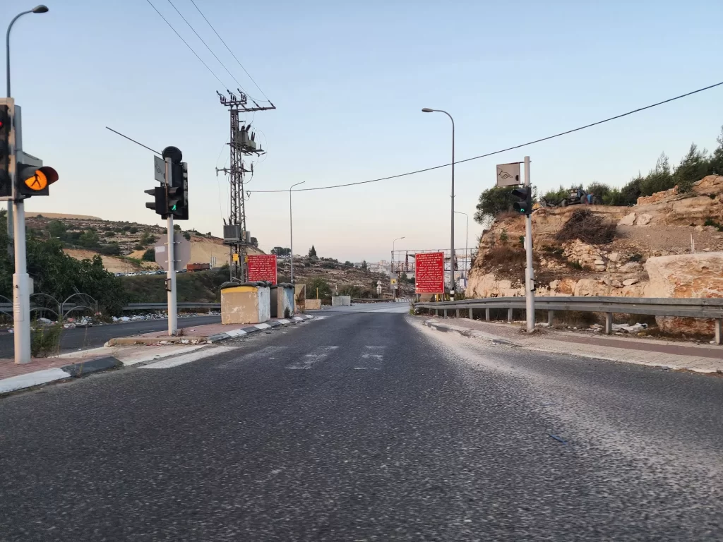
One of the most noticeable changes in the landscape surrounding the road has been the wall that has been put up between the Palestinian urban population and the road. Due to the violent terrorist attacks that occurred throughout Israel during the early 2000’s, and did not skip this road, Israel constructed a security barrier allowing it to stop the penetration of the violet terrier attacks into its area, and against its citizens. The overwhelming majority of this security barrier is a very sophisticated fence. Yet in some places, mainly around Jerusalem and places very close to adjacent urban populations on both sides of the barrier a wall was constructed. One who drives road 60 south of Jerusalem towards Gush Etzion is confronted with this wall that hides behind it the urban city of Bethlehem and its satellite towns.
I rarely enter the city of Bethlehem anymore, as the Israeli government prohibits Jewish Israeli citizens from entering area A, areas in the west bank under the authority of the PA. This prohibition is clear and presented on big red signs along the road marking the entrance to area A, areas under full Palestinian control, civil and security administration. Israeli Jewish citizens are asked not to enter these areas, as Israel has no official security presence there and can’t vouch for your safety. Every once in a while, I will enter with client-tourists that have interest in visiting the holy Christian sites such as the Church of Nativity or are interested in meetings with members of the Palestinian authority or local citizens as part of their attempt to understand the ‘situation’. But I do travel road 60 south quite often, to visit my parents, and with tourists, as the Gush Etzion region is a beautiful area with lots of historical and modern Zionist sites, attractions, and nature.
Today, the segment of Road 60 that I traverse to the south is a shared thoroughfare utilized by both Israeli and Palestinian citizens, just like the majority of the main roads in the West Bank. The route I take back from Jerusalem, Road 1 heading east, past Ma’ale Adumim, follows the same pattern. Road 60 to the south serves as the primary conduit for Israeli citizens journeying to Gush Etzion, Hebron, and its environs, and it serves a similar purpose for Palestinians traveling from Bethlehem to Hebron and its surrounding areas. Road 1 to the east connects Jerusalem with Jewish communities to its eastern periphery, and more significantly, it serves as the gateway to Road 90, which runs along the eastern flank of Israel, leading north or south through the country. It is also the central route connecting Ramallah and Jericho, and of even greater importance, it forms the passageway linking the northern and southern regions of the West Bank via the eastern Jerusalem bypass. These examples merely scratch the surface, as there are numerous shared roads throughout the West Bank. A notable manifestation of this shared space is the diverse mix of car license plates, featuring both Israeli and Palestinian designations, encountered while driving on these roads.
When I explain the concept of shared roads, people’s primary concern often centers on security. I comprehend their apprehensions. Firstly, the global perception of the West Bank is frequently associated with violence. Many foreigners, once they cross a checkpoint into areas of the West Bank under Israeli control (Area C) and traverse shared roads, experience a degree of surprise as they may not immediately discern the differences between the areas; it can all seem like a continuous landscape until the distinctions are pointed out. This often contrasts with the volatile image they have from abroad. Secondly, I don’t underestimate the reality of the situation. Violence and terror attacks have occurred in the past and continue to happen along these shared roads. After all, a shared road is precisely where one encounters what some may term friction and others might describe as interaction between the two populations. In places where Jews and Palestinians share a presence, it can be relatively easier for individuals with malicious intentions to carry out attacks, compared to areas characterized by strict separation. Those attuned to this context wouldn’t find it challenging to locate one or more memorials along the roadside, commemorating Israeli citizens who have tragically fallen victim to these circumstances.
Nevertheless, there are multiple perspectives to consider when it comes to these shared roads, including our ever-evolving Road 60. I acknowledge the complexities of the situation but would like to offer an alternative viewpoint. While there is no formal coexistence between Palestinians and Israeli citizens, there is, in a way, a shared existence along these roads.
Prominent signs have been installed along the roads, urging, if I may say, imploring drivers to exercise caution. These signs are posted in English, Arabic, and Hebrew. Regardless of their background, the vast majority of people who travel these roads daily share a common objective: to return home safely. An accident is an accident, irrespective of whether it involves Palestinians or Israelis.
In numerous regions, you can discover Israeli Industrial Zones and shopping areas within the West Bank. These are also located in areas under Israeli control (Area C), where Palestinians have the freedom to move around and work without restrictions. Thousands of Palestinians work each day in these areas, some in Israeli-Jewish-owned factories and businesses, and others in Palestinian-owned enterprises. The overwhelming majority of those engaged in work or shopping within these locales share the same fundamental goal: to provide for their families. Once again, these areas serve as examples where interactions and potential frictions between Israeli-Jewish citizens and Palestinians can occur. It’s another instance of shared existence rather than formal coexistence.
In today’s world, divisions and cultural separations often breed ignorance about one another, ultimately paving the way for the demonization of the other, the cultivation of hatred, and even the escalation of violence. While Israel should continue its efforts to reduce its political and security presence over Palestinian citizens and aspire to a strong and responsible Palestinian Authority capable of addressing their civil and safety needs, Israeli citizens should seek ways to foster positive engagement with their neighbors. For the time being, this engagement largely unfolds along our shared roads and common areas in the West Bank.
The Jewish-Israeli and Palestinian experiences often first intersect for Israelis, frequently through their service in the IDF, shaping a primarily military perspective. Regrettably, for many, this constitutes their sole interaction with Palestinians, aside from how they are portrayed in the media and cultural representations. Israelis who do not travel through the West Bank and lack personal, human, and civil interactions with Palestinians tend to form their beliefs, political views, and understanding of the Palestinian people through these limited lenses.
Conversely, Jewish-Israeli settlers’ encounters with Palestinians can be much more frequent, sometimes even daily. These interactions, or frictions, occur in various contexts such as shared roads, car accidents, car washes, construction work, factories, gas stations, shops, and more. They can vary in nature, ranging from routine and amicable to less pleasant or even violent, generating fear and tension between the two societies. Some classic rhetoric from Jewish settlers emphasizes their proximity to Palestinians, asserting that they understand them better due to their day-to-day interactions. They claim, “We, the settlers, know the Palestinians – we live side by side, we know their nature. Jews living in Tel Aviv, the Dan region, or anywhere else in Israel really have no idea.” They further contend, “The Jewish settlers in the West Bank are not the problem; they are the solution, as they de facto live alongside the Palestinians.” Their beliefs, political views, and comprehension of the Palestinian situation are molded through these experiences.
I reflect on these encounters every time I travel along Road 60 to visit my parents in Efrat, my hometown, or when I accompany clients to the numerous tourist sites and attractions in the region. My interactions with Palestinians have evolved and diminished over the years, much like the road itself, which has shifted and transformed. Road 60 predominantly serves as a shared road, a shared existence where Palestinians and Israelis coexist side by side, or perhaps side by side in a car, waiting patiently in traffic, hoping for the day when road construction would be completed. I hold hope that we can establish more spaces along Road 60 where citizens from both sides can engage in positive experiences, perhaps at a café like Aroma or Starbucks, fostering interactions and personal connections. In doing so, they can come to know one another on a more human and personal level. With any luck, the road will contribute to building understanding and mutual respect, rather than perpetuating ignorance, intolerance, and demonization.
[1] Trace the path of the Book of Genesis – Abraham, Isaac, and Jacob all traversed this route.
[2] Repairing the road for the Ola Regal – Pilgrims; see Mishnah Shekalim 1, 1; Tosefta Shekalim 1,1.